Weber River bypass reach flows
PacifiCorp's Weber hydroelectric plant on the Weber River includes several public recreation components. During the most recent relicensing, additional flow information was desired regarding the bypass reach between the diversion dam and the Weber Plant as this reach could provide opportunities for recreation, depending on the time of year and the availability of water.
Disclaimer: PacifiCorp is not promoting or inviting the public to participate in activities on the Weber River bypass reach. The public should exercise caution when in the bypass reach and use it at their own risk.
The Weber hydroelectric plant bypass reach starts at the diversion dam 0.2 miles west of the Interstate 80 rest area exit and ends at the Weber plant 2.0 river miles downstream (see figure below). The flows shown in the table are calculated based on the United States Geological Survey streamflow gage 1.0 miles upstream of the diversion dam, minus the flow being diverted for power at the diversion dam. There is a minimum required flow in the bypass reach that varies seasonally. From April 1 to September 30, the flow is between 34 and 50 cubic feet per second, based on the April 1st runoff forecast. The rest of the year, the minimum required flow is 34 cubic feet per second.
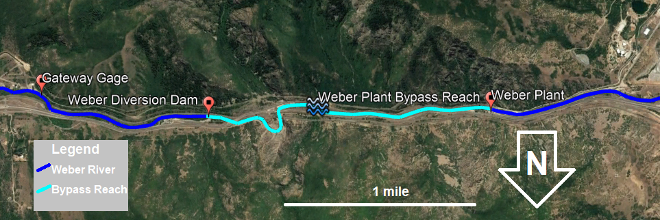
Table: 7-day hourly average flow rates in cubic feet per second
* Passing only minimum flow (34-50 cubic feet per second)
NA: Not Available
Graph: Last 24 hours average flow rates
Flow rates as of local time
These water management data are provisional readings of current river flow conditions. Beware and use data at your own risk. River flows can change dramatically due to operational changes at the dam or due to weather conditions.